Ecological Monitoring of Spoon-billed Sandpiper Habitats
Understand the intersection of environmental policy, infrastructure, and the role of data-driven conservation.
30-Second TL;DR
What Changed
Coastal wetlands provide critical ecosystem services like carbon sequestration and storm protection.
Why It Matters
Highlights the growing importance of integrating ecological data into urban planning and infrastructure development.
What To Do Next
Consider how geospatial AI and satellite imagery can be used to monitor habitat changes and support conservation efforts.
Key Points
- •Coastal wetlands provide critical ecosystem services like carbon sequestration and storm protection.
- •Infrastructure projects often conflict with protected habitats, requiring better ecological impact assessments.
- •Flagship species like the Spoon-billed Sandpiper are essential for public awareness and policy advocacy.
Deep Insight
Background and context from public sources — not the original article. 24 sources cited.
Enhanced Key Takeaways
- •The Spoon-billed Sandpiper's drastic population decline, estimated at over 80% since the 1970s, is primarily attributed to extensive intertidal habitat loss in the Yellow Sea region due to land reclamation and significant subsistence hunting in its wintering grounds in Southeast Asia, particularly Myanmar and Bangladesh.
- •International conservation efforts, such as the East Asian-Australasian Flyway Partnership (EAAFP) and the 'headstarting' program (captive breeding and release of chicks), are crucial strategies to boost the species' numbers and coordinate protection across its migratory route.
- •China has implemented significant policy changes, including a ban on further coastal land reclamation and the inscription of key Yellow Sea coastal wetlands, such as Tiaozini, as UNESCO World Heritage Sites, which has been instrumental in slowing the species' annual decline.
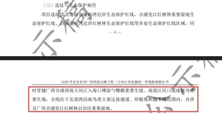
- •Despite these protective measures, new infrastructure projects, such as a recently approved coastal highway in Guangxi, China, continue to pose an immediate threat by encroaching upon important Spoon-billed Sandpiper habitats.
- •Advanced remote sensing technologies, including the Remote Sensing Ecological Index (RSEI) and Landsat imagery, are increasingly utilized in China for objective, rapid, and large-scale monitoring and assessment of coastal wetland ecological quality.
Technical Deep Dive
- Satellite Tagging: Tiny satellite tags are glued to the birds' back feathers to track their migration routes and identify critical stopover sites, providing vital information for targeted conservation efforts.
- Remote Sensing Ecological Index (RSEI): This integrated index, which does not require manual weight determination, is used for rapid and objective assessment of ecological environmental quality in coastal wetlands, leveraging geospatial data.
- Landsat Imagery: Time-series data from Landsat satellites are employed to monitor landscape changes and interpret wetland types, helping to analyze the rate of change and characteristics of different wetland categories over decades.
- Comprehensive Monitoring Systems: China is developing integrated monitoring systems covering shorelines, sea, and sky to investigate marine ecology, carbon sinks, and formulate ecosystem health early warning systems.
Future ImplicationsAI analysis grounded in cited sources
Timeline
- 1970sSpoon-billed Sandpiper breeding population estimated at 2000-2800 pairs, beginning a significant decline.
- 2004IUCN Red List status upgraded from 'Vulnerable' to 'Endangered'.
- 2008IUCN Red List status upgraded to 'Critically Endangered'; major overwintering population discovered in Myanmar's Gulf of Mottama.
- 2012The 'headstarting' captive breeding program is initiated to boost wild populations.
- 2017Myanmar's Gulf of Mottama awarded international protection; Greenpeace highlights threat to Tiaozini mudflats; China mandates 'ecological red lines' for environmental protection.
- 2019Yellow Sea coastal wetlands, including Tiaozini, are inscribed as UNESCO World Heritage Sites.
Sources (24)
Factual claims are grounded in the sources below. Forward-looking analysis is AI-generated interpretation.
Weekly AI Recap
Read this week's curated digest of top AI events →
AI-curated news aggregator. All content rights belong to original publishers.
Original source: 虎嗅 ↗
This is a summary, not the original. Read the source, or get the weekly briefing.
The weekly digest
One email a week. Unsubscribe anytime.