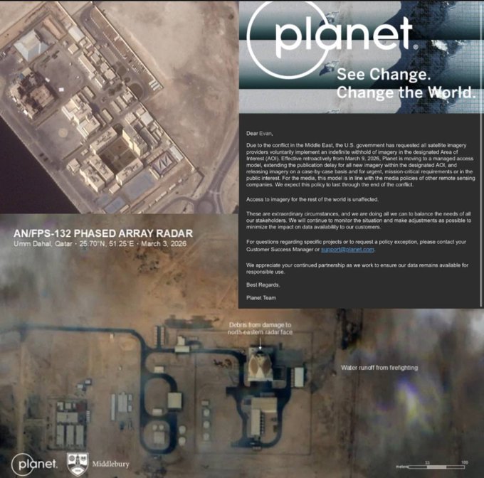
US Bans Satellite Images of Key Areas
💡Satellite data restrictions hit geospatial/CV AI data pipelines for training & analysis
⚡ 30-Second TL;DR
What Changed
US govt mandates voluntary indefinite suspension of AOI satellite imagery releases
Why It Matters
Restricts public access to recent satellite imagery, potentially disrupting geospatial AI training datasets and real-time monitoring applications. AI practitioners in earth observation may need to pivot to alternative sources like open satellite data.
What To Do Next
Audit your geospatial models for AOI data dependency and integrate ESA Sentinel-2 as backup.
Key Points
- •US govt mandates voluntary indefinite suspension of AOI satellite imagery releases
- •Triggered by Iranian strike revealing damage to US military bases
- •Applies to all satellite imagery service providers
🧠 Deep Insight
AI-generated analysis for this event.
🔑 Enhanced Key Takeaways
- •The directive is being enforced through the Department of Commerce's National Oceanic and Atmospheric Administration (NOAA), which holds the authority to impose 'shutter control' under the Land Remote Sensing Policy Act.
- •Commercial imagery providers are concerned that this 'voluntary' request creates a precedent for government-mandated censorship, potentially impacting their ability to fulfill contracts with international media and non-governmental organizations.
- •The policy specifically targets high-resolution synthetic aperture radar (SAR) and optical imagery, which are capable of penetrating cloud cover and identifying structural damage to hardened military infrastructure.
🔮 Future ImplicationsAI analysis grounded in cited sources
⏳ Timeline
Weekly AI Recap
Read this week's curated digest of top AI events →
👉Related Updates
AI-curated news aggregator. All content rights belong to original publishers.
Original source: cnBeta (Full RSS) ↗