🇨🇳cnBeta (Full RSS)•Freshcollected in 31m
UK Army Tests AI Drones for Faster Mine Clearance
💡UK military advances AI drones for demining—insights for AI in robotics apps.
⚡ 30-Second TL;DR
What Changed
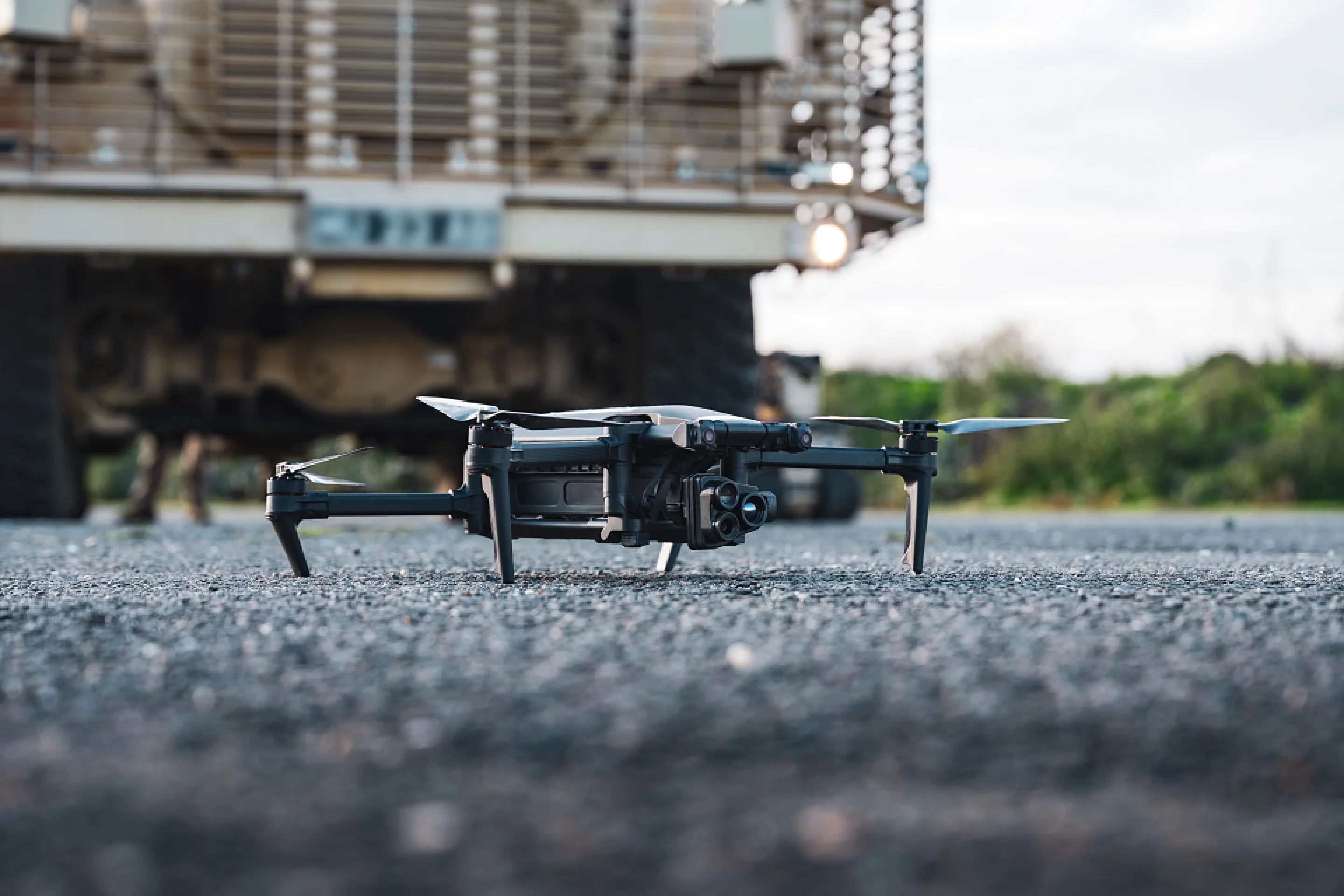
British Army and Dstl tested AI drones for mine detection.
Why It Matters
Successful tests could accelerate adoption of AI drones in military demining worldwide, expanding AI applications in defense. This may influence commercial drone tech for hazardous inspections.
What To Do Next
Explore Dstl's AI sensor integration for developing autonomous inspection drones.
Who should care:Developers & AI Engineers
🧠 Deep Insight
AI-generated analysis for this event.
🔑 Enhanced Key Takeaways
- •The initiative is part of the UK Ministry of Defence's 'Project Synergia,' which focuses on integrating autonomous systems to reduce the 'human-in-the-loop' requirement for high-risk explosive ordnance disposal (EOD) tasks.
- •The drones utilize multi-spectral imaging and synthetic aperture radar (SAR) to identify subsurface anomalies that traditional metal detectors often miss, particularly in complex terrain or soil conditions.
- •Data collected during the Essex trials is being fed into a centralized 'Digital Twin' of the battlefield, allowing commanders to visualize mine density in real-time and optimize clearance routes for ground troops.
📊 Competitor Analysis▸ Show
| Feature | UK Army/Dstl AI Drones | US Army (xM1210) | Ukrainian 'Sting' Drone |
|---|---|---|---|
| Primary Sensor | Multi-spectral/SAR | Ground Penetrating Radar | Visual/Thermal |
| Autonomy Level | High (Autonomous Mapping) | Medium (Semi-autonomous) | Low (Manual/FPV) |
| Deployment Focus | Large-area clearance | Tactical pathfinding | Frontline combat |
🛠️ Technical Deep Dive
- Sensor Fusion: Combines high-resolution optical cameras with miniaturized Ground Penetrating Radar (GPR) to correlate surface visual data with subsurface density variations.
- Edge Computing: On-board NVIDIA Jetson-based processing units perform real-time image segmentation to classify potential UXO (Unexploded Ordnance) without requiring a constant data link to a ground station.
- Navigation: Utilizes SLAM (Simultaneous Localization and Mapping) algorithms to maintain precise positioning in GPS-denied environments, critical for accurate mapping of minefields.
🔮 Future ImplicationsAI analysis grounded in cited sources
Deployment of these systems will reduce EOD personnel casualty rates by at least 40% in active conflict zones.
By automating the detection phase, human operators are removed from the immediate vicinity of unmapped minefields during the initial survey.
The UK will integrate these AI drones into NATO's standard operating procedures for rapid area denial clearance by 2028.
The successful validation in Essex provides the necessary data to push for interoperability standards across allied forces.
⏳ Timeline
2023-09
Dstl initiates Project Synergia to explore autonomous EOD capabilities.
2024-11
Initial laboratory testing of AI-driven subsurface detection algorithms.
2026-03
Commencement of field trials in Essex, UK.
📰
Weekly AI Recap
Read this week's curated digest of top AI events →
👉Related Updates


;text-align: center;text-wrap-mode: wrap;background-color: rgb(26, 26, 26);position: static;visibility: visible;width: 550px;height: 321px;display: block;flex-grow: 1"></iframe></p><p>任务在上周完成绕月飞行后顺利返航,苹果公司首席执行官Tim Cook和全球营销高级副总裁格雷格·乔斯维亚克(Greg Joswiak)也先后通过社交媒体发文祝贺,并重点强调了 iPhone 在本次任务中的参与度。</p><p><img src="https://static.cnbetacdn.com/article/2026/0412/9e13c208106461d.jpg)
AI-curated news aggregator. All content rights belong to original publishers.
Original source: cnBeta (Full RSS) ↗