🇨🇳cnBeta (Full RSS)•Stalecollected in 8h
Jilin-1 Launches 8 Sats, HD Images First Orbit
💡Largest commercial imaging constellation grows: fresh sub-meter data fuels CV/AI Earth models.
⚡ 30-Second TL;DR
What Changed
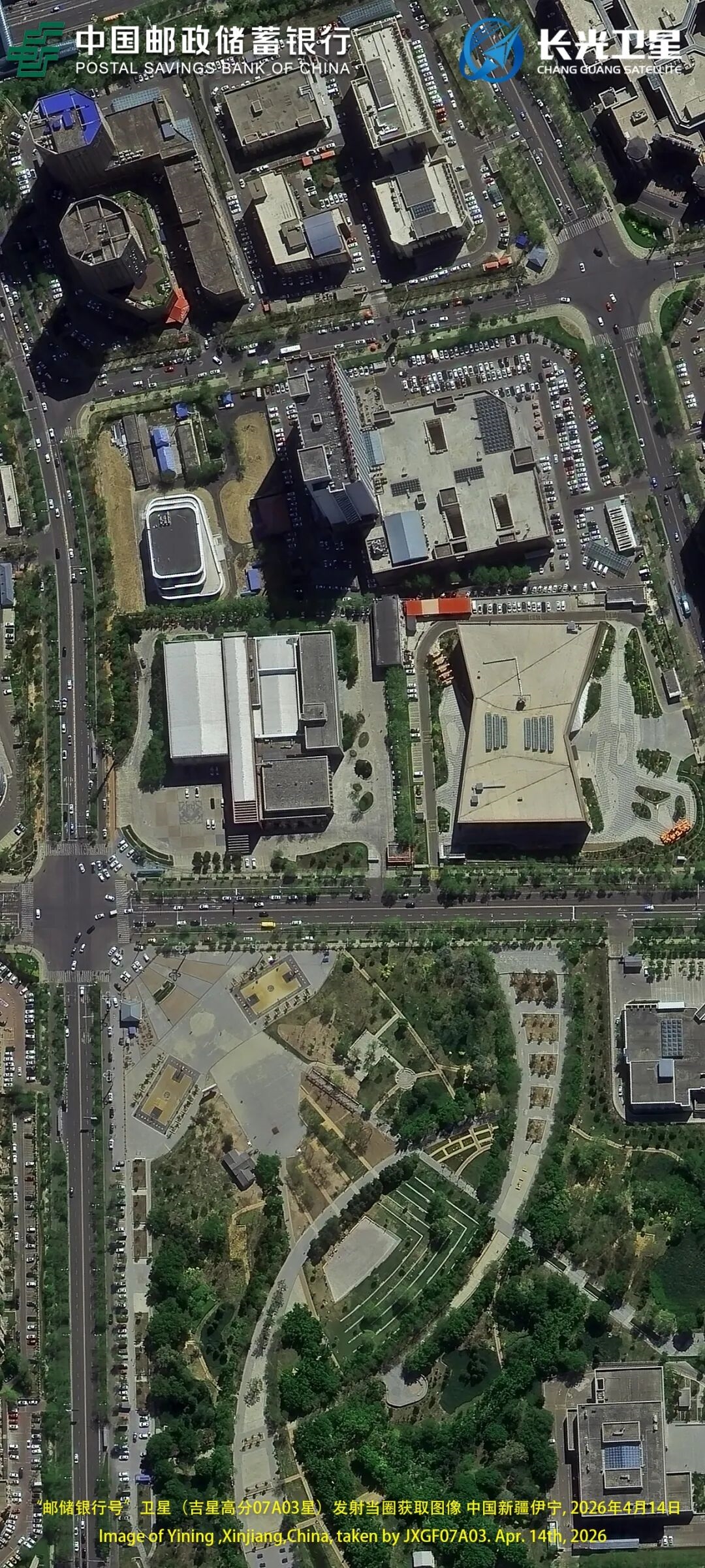
April 14 launch of 8 high-res optical remote sensing satellites
Why It Matters
Bolsters global high-res imagery supply for AI computer vision training and geospatial apps. Enhances commercial data access for researchers and enterprises building Earth observation models.
What To Do Next
Query Jilin-1 data portal for sub-meter imagery to augment your vision model datasets.
Who should care:Researchers & Academics
Key Points
- •April 14 launch of 8 high-res optical remote sensing satellites
- •Specific sats: Jixing 07A02-04, 07B02-04, 07C02-03
- •Total in-orbit: 152, largest sub-meter commercial constellation
- •Goal: 300 sats by 2027 for all-weather global coverage
- •HD images successfully transmitted on first orbit
🧠 Deep Insight
AI-generated analysis for this event.
🔑 Enhanced Key Takeaways
- •The launch was conducted by Chang Guang Satellite Technology (CGST) using a Long March 2D carrier rocket from the Taiyuan Satellite Launch Center.
- •The Jilin-1 constellation utilizes a modular design approach, allowing for rapid iteration and deployment of different satellite variants (A, B, and C series) to optimize cost and performance.
- •The constellation's expansion is supported by the 'Jilin-1' commercial remote sensing data service platform, which provides real-time data access to government and commercial clients for agriculture, forestry, and urban planning.
📊 Competitor Analysis▸ Show
| Feature | Jilin-1 (CGST) | Planet Labs | Maxar Technologies |
|---|---|---|---|
| Primary Focus | Sub-meter optical/video | Daily global revisit (medium res) | High-res/VHR imagery |
| Constellation Size | ~152 (Sub-meter) | ~200+ (Doves/SkySats) | ~4 (WorldView/Legion) |
| Data Type | Optical/Video/Hyperspectral | Optical (Medium/High) | VHR/SAR/3D Elevation |
🛠️ Technical Deep Dive
- •Satellite Bus: Modular, lightweight architecture designed for high-density launch configurations.
- •Imaging Capabilities: Capable of sub-meter resolution (typically 0.5m to 0.75m) with video-capable imaging modes for dynamic target tracking.
- •Data Transmission: High-speed X-band downlink systems for rapid image delivery post-acquisition.
- •Orbit: Primarily Sun-Synchronous Orbit (SSO) to ensure consistent lighting conditions for remote sensing applications.
🔮 Future ImplicationsAI analysis grounded in cited sources
CGST will achieve a global revisit rate of under 30 minutes by 2027.
The planned expansion to 300 satellites significantly increases the frequency of overpasses for any given point on Earth.
Jilin-1 will integrate AI-on-board processing for real-time edge analytics.
The shift toward all-weather coverage and rapid data delivery necessitates reducing latency by processing imagery directly on the satellite.
⏳ Timeline
2015-10
Launch of the first four Jilin-1 satellites, marking the start of China's first commercial remote sensing constellation.
2020-09
Successful launch of 9 Jilin-1 Gaofen-03 satellites, demonstrating rapid deployment capabilities.
2022-05
Launch of Jilin-1 Kuanfu-01C, expanding the constellation's wide-swath imaging capabilities.
2023-06
Record-breaking launch of 41 Jilin-1 satellites in a single mission, significantly increasing constellation capacity.
2025-01
CGST reaches the 100-satellite milestone in orbit, solidifying its position as a major global commercial provider.
📰
Weekly AI Recap
Read this week's curated digest of top AI events →
👉Related Updates


AI-curated news aggregator. All content rights belong to original publishers.
Original source: cnBeta (Full RSS) ↗