🗾ITmedia AI+ (日本)•較早收集於 82m
JAXA 地球觀測資料 API v0.1.5 支援 MCP,適用生成 AI 工具
#earth-observation#api-update#genai-integrationjaxa-earth-api-for-pythonjaxajaxa-earth-api
💡透過新 MCP 支援,在生成 AI 工具存取 JAXA 衛星資料—完美適合地球觀測 AI!
⚡ 30-Second TL;DR
有什麼變化
發布 JAXA Earth API for Python v0.1.5
為什麼重要
這連接衛星資料與 AI 工作流程,有助環境 AI 應用。開發者可無縫將 JAXA 資料整合至基於 LLM 的分析管線。
下一步行動
透過 pip 安裝 JAXA Earth API v0.1.5,並在 LangChain 或 LlamaIndex 應用中測試 MCP 整合。
誰應關注:Developers & AI Engineers
關鍵要點
- •發布 JAXA Earth API for Python v0.1.5
- •新增 MCP 相容性,適用生成 AI 工具
- •支援地球觀測資料視覺化
- •可在 AI 環境中進行分析
🧠 深度解析
背景與延伸:來自公開資料,非原文內容。引用 6 個來源。
🔑 增強重點摘要
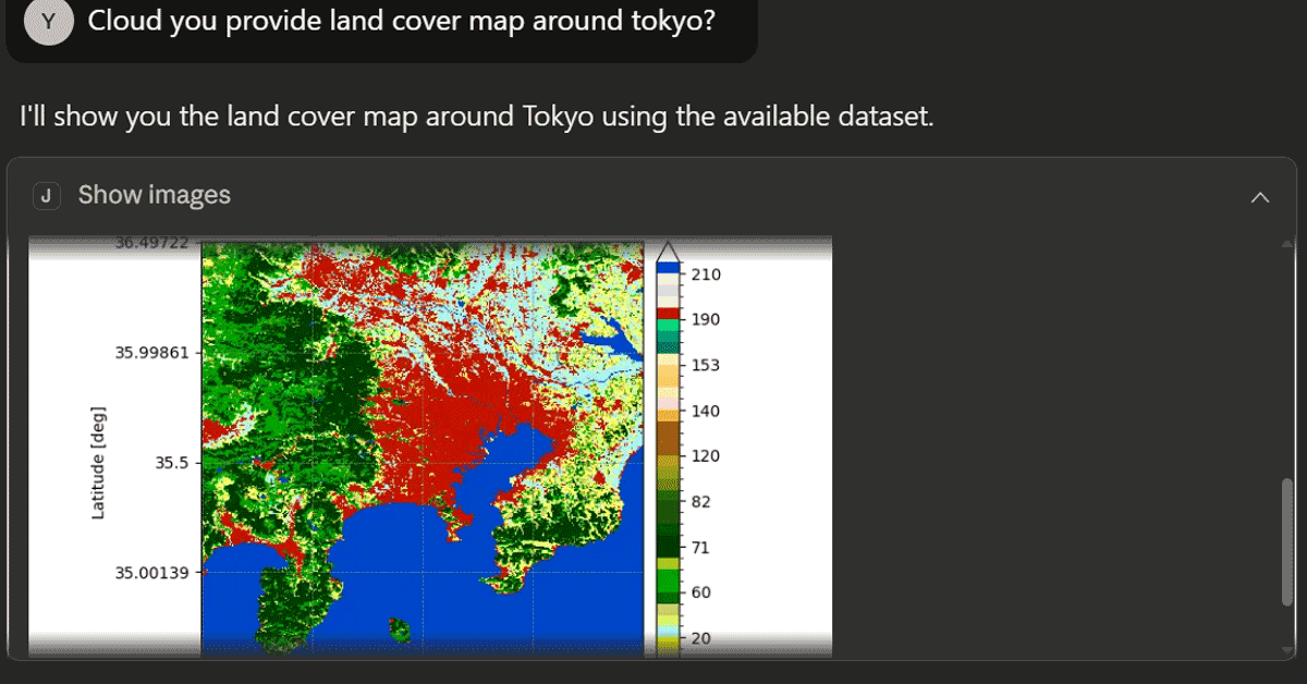
- •JAXA Earth API for Python v0.1.5 integrates with Claude Desktop through MCP (Model Context Protocol) server functionality, enabling generative AI tools to directly query and visualize satellite observation data without manual API calls[1]
- •The API provides four core MCP-compatible functions: search_collections_id for metadata retrieval, show_images for satellite visualization, calc_spatial_stats for statistical analysis, and show_spatial_stats for results visualization[1]
- •The implementation requires local Python virtual environment setup with mcp package dependencies, allowing researchers to process JAXA's multi-sensor Earth observation datasets (including ALOS, GCOM-W, and PRISM instruments) within AI workflows[1][2]
🛠️ 技術深入
MCP Server Integration Architecture:
- Requires jaxa-earth-0.1.5 package installation in isolated Python venv with mcp dependency
- MCP server script (mcp_server.py) deployed to stable path accessible from Claude Desktop configuration
- Python interpreter path explicitly referenced in Claude Desktop config pointing to venv executable
Core API Processing Pipeline:
- ImageCollection class: chains filter_date(), filter_resolution(), filter_bounds(), select(band), get_images() methods
- ImageProcess class: supports show_images(), calc_spatial_stats(), show_spatial_stats(), calc_temporal_stats(), mask_images() operations
- FeatureCollection class: reads GeoJSON geometries for spatial filtering with select() method
- Spatial statistics output includes mean, std, min, max, median values stored in timeseries property[2]
Data Processing Constraints:
- Masking operations require identical raster shape and resolution between data and mask layers
- Method_query parameter supports three filtering modes: 'range', 'values_equal', 'bits_equal' (default: values_equal)
- stac_ppu (pixels per unit) parameter must be set before raster retrieval[2]
🔮 前景展望AI analysis grounded in cited sources
MCP standardization accelerates AI-native Earth observation workflows
Direct Claude Desktop integration removes API abstraction layers, enabling non-specialist researchers to conduct satellite analysis through conversational AI interfaces.
JAXA positions Japanese satellite data as AI-accessible infrastructure
MCP compatibility signals JAXA's strategic alignment with generative AI adoption, potentially increasing utilization of ALOS, GCOM-W, and PRISM datasets among AI-first organizations.
⏳ 時間線
2024-01
JAXA Earth API for Python initial release with core ImageCollection and FeatureCollection classes
2025-06
Version 0.1.3 released with enhanced spatial statistics and temporal analysis capabilities
2026-02
Version 0.1.5 released with MCP server support for Claude Desktop integration
📎 來源 (6)
Factual claims are grounded in the sources below. Forward-looking analysis is AI-generated interpretation.
📰
AI 週報
閱讀本週精選 AI 大事摘要 →
👉相關動態
AI 策展新聞聚合。所有內容版權歸原始發布者所有。
原始來源: ITmedia AI+ (日本) ↗
每週 AI 簡報
每週一封,可隨時退訂。